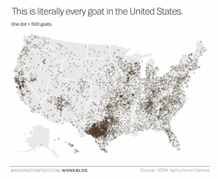
I think the title of the post, and the title of the map are pretty self explanatory. This is the first post in a while, so might as well make it a fun one right? Head over to the Washington Post to learn more about the map, and its purpose.
 |
|
| I think the title of the post, and the title of the map are pretty self explanatory. This is the first post in a while, so might as well make it a fun one right? Head over to the Washington Post to learn more about the map, and its purpose.
0 Comments
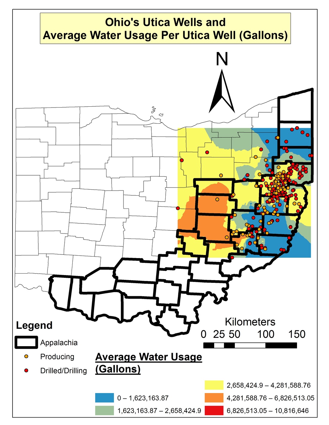
I was looking at this map of water usage by frackers in Ohio and was thinking about my times in early cartography class. I wanted to throw this out to the people that check out this blog and see what you think about it; Do you think it is well made? Where is the source information? Why do I find it hard to read? Am I losing my mind?
Anyways, if you would actually like to know about water and chemical usage dealing with fracking in Ohio check out the source link. [Fractracker] 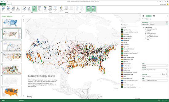 Microsoft announced yesterday that it has updated its Power Map Preview functionality on Excel to allow for easier visualization of data that was entered by either address, or by latitude and longitude. Check out more info and a video after the break. By: The Male Cheerelader 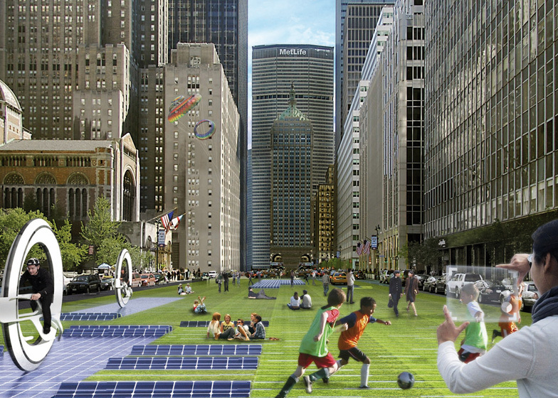
Imagine a corridor from Boston to Washington DC that uses a number of innovative forms of future travel to make the commute in record times. That is exactly what design firm Howeler + Yoon Architecture did, and it looks pretty dang cool. By: The Male Cheerleader 
I will be taking a couple weeks off as we celebrate the next couple weeks. I also broke the charger to my computer so it is a little bit difficult to post without a computer....anyways, read up on some holidays other than your own. It can help bring you closer to our global brothers and sisters.
http://kids.nationalgeographic.com/kids/stories/peopleplaces/winter-celebrations/ By: The Male Cheerleader 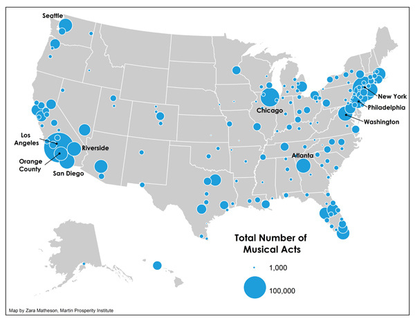
Music and place go hand in hand and over at The Atlantic Cities they understand this and have created the above map showing the number of musical acts in metro areas. The author, Richard Florida, has written a number of articles discussing the role of place in music, all of which are fascinating. So click the source link and learn more before you head out to your next show at Bogart's, The Grog Shop, or The Fillmore.
[via The Atlantic Cities] By: The Male Cheerleader 
Earlier this year fifteen leaders of the US Armed Forces expressed concern about how climate change could cause instability in regions, and cause international tensions. Now the US National Intelligence Council is taking notice. Editor’s Note: Yarbography is proud to repost this article courtesy of Natural Resources Defense Council. Author credit goes to Kaid Benfield. 
In Jeff Speck’s excellent new book, Walkable City, he suggests that there are ten keys to creating walkability. Most of them also have something to do with redressing the deleterious effects caused by our allowing cars to dominate urban spaces for decades. I don’t necessarily agree with every detail, and my own list might differ in some ways that reflect my own experience and values. But it’s a heck of a good menu to get city leaders and thinkers started in making their communities more hospitable to walkers. By: The Male Cheerleader 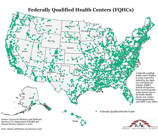
A Federally Qualified Health Center (FQHC) is a not-for-profit organization that is set up to offer comprehensive primary care to vulnerable populations, and is funded by the federal Health Resources and Services Administration (HRSA). The above map shows all of these FQHC's throughout the country, so have a look and read past the break to learn more about how these organizations are helping undocumented immigrants. By: The Male Cheerleader 
Seeing Earth from space gives one a whole new perspective on their surroundings. Taking satellite pictures of Earth can create very artistic looking pieces. Glaciers, lava flows, forests, alluvial fans, and deltas can all work together to create beautiful imagery. Nasa has created a free ebook, called Earth as Art. to show off some of these gorgeous images.
[via NASA] | Yarbographers:


The Vegan
Name: Corey Major: B.A. Human Geography, M.A. Human Geography, PhD Student in Cultural Studies 
The Guy with the Beard
Name: Craig Major: B.A. Physical Geography, Certificate in GIS 
The Gas Man
Name: Matt Major: B.A. Physical Geography, Certificate in GIS ArchivesFebruary 2015 CategoriesAll |
 RSS Feed